Rowan researchers deploy 3D mapping tools to define fossil layer
Rowan researchers deploy 3D mapping tools to define fossil layer
November 8, 2021
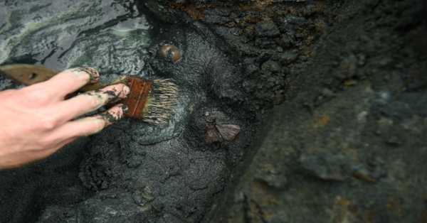
Clearing fossils from the bonebed
A team of Rowan University researchers, led by faculty and including students and volunteers at the Jean & Ric Edelman Fossil Park in Mantua Township, have deployed high-resolution technology to resolve one of the oldest of mysteries – the precise geometry of an ancient, regional bonebed.
The bonebed, an abundantly rich source of vertebrate and invertebrate fossils within the Fossil Park where many of its massive sea turtles, crocodiles and mosasaurs have been found, lies about 40 feet below ground level in the former marl quarry and is known to researchers as the Main Fossiliferous Layer, or MFL.
Within a rock horizon known as the Hornerstown Formation, the MFL stretches from central New Jersey to northern Delaware but, until recently, its precise position and thickness of the MFL within this rock unit was misunderstood. Previously thought to be about 30 centimeters thick, the MFL was actually found by the Rowan research team to be much narrower, about 10 centimeters thick, and that there is another rich source of fossils roughly 10 centimeters below the MFL comprised largely of oyster fossils.
“We combined traditional paleontological methodologies with 3D spatial analyses to identify two separate fossil layers in this interval of the Hornerstown Formation,” said Dr. Kristyn Voegele, an assistant professor of Geology within the School of Earth & Environment who led the study. “This work synthesizes prior reports that disagreed about the placement of the MFL because many (researchers) thought there was only one fossil layer.”
Voegele said the work, based on a study of some 1,300 fossils at the Fossil Park over two years, is significant in its own right and as a building block for ongoing research.
Edelman Fossil Park contains an unusually rich abundance of fossilized animal remains, many of them examples of marine life that perished, along with roughly three-fourths of planetary life and virtually all of the dinosaurs, after an asteroid slammed into Earth just off the Yucatan Peninsula some 66 million years ago.
Their findings were published Nov. 1 under the heading “Microstratigraphic Analysis of Fossil Distribution in the Lower Hornerstown and Upper Navesink Formations at the Edelman Fossil Park,” in the open-access journal Frontiers in Earth Science.
Rowan also recently celebrated a groundbreaking on Oct. 9 for a new $73 million museum at the Fossil Park, a 65-acre former quarry that’s virtually teeming with fossils. In fact, the site is so rich that all 1,300 of the specimens analyzed in the new study by Voegele and colleagues came from just a one square meter section of the MFL.
The research group included Fossil Park volunteers who helped locate and collect the fossil specimens and students who digitized the paper quarry map, uploaded data about fossil locations to GPS-enabled 3D modeling software, and analyzed the positions of the fossils in 3D space.
Voegele said that combining those techniques with traditional paleontological work is likely to inspire broader use of 3D technology for mapping and analyzing active dig sites. She added that the research will be especially significant to fellow scientists studying the MFL within the Hornerstown Formation, which is known to occur at a number of other localities across central New Jersey and possibly in northern Delaware.
“The real significance of the study is building a consistent definition of the MFL so it can be recognized by others studying the Hornerstown Formation,” Voegele said.
Importantly, the study was also a community science effort as this project includes two Rowan undergraduates, a Stockton University undergraduate who interned at the Fossil Park, and two long-time Edelman Fossil Park volunteers. Additionally, the interdisciplinary collaboration between the Department of Geology and the Department of Geography, Planning, and Sustainability was essential for the incorporation of the 3D analyses.
Researchers contributing to the study included: Voegele; Dr. Paul Ullmann, assistant professor in the Department of Geology; Tara Lonsdorf ’21, a Department of Geology alumna now pursuing a Ph.D. at University of Michigan; Dr. Zachary Christman, an associate professor in the Department of Geography, Planning, and Sustainability; Michael Heierbacher, a longtime EFP volunteer; Brian Kibelstis, a former EFP summer intern from Stockton University; Ian Putnam, a longtime EFP volunteer); Dr. Zachary Boles, a lecturer in the Department of Geology and research coordinator at the EFP; Shane Walsh, a Department of Geography, Planning, and Sustainability alumnus and now an Environmental Specialist at the Bureau of Water Allocation and Well Permitting within the NJDEP; and Dr. Kenneth Lacovara, founding dean of the School of Earth & Environment and EFP director.